While not rare, it is a pleasant surprise to see a fairly quiet radar mosaic stretching from coast to coast. Unless you are specifically looking for nasty weather, a tranquil radar usually means decent flying weather, outside of cold clouds, in most locations that are not reporting low ceilings and reduced visibility due to a radiation fog event. This also means you may not see some of the other familiar markers you’d normally expect to be displayed on the Map with the radar layer on. One of these markers that is often missing is the echo top heights.

First, let’s get one thing out of the way; echo tops are not the same as cloud tops. Cloud tops are always higher. Second, echo tops represent the mean sea level (MSL) height of the highest radar echo of 18 dBZ or greater. Third, echo tops heights are added to the NEXRAD mosaic in ForeFlight only when the echo tops consistently exceed 20,000 feet MSL. In other words, you won’t see an echo tops report of 15,000 feet, for example. So it’s understandable for customers to believe echo tops may be “missing” from the radar mosaic when the radar is fairly benign. Moreover, there may be some intense-looking echoes in various locations, even some with storm tracks and mesoscale circulations shown, but no echo top heights anywhere to be found. Let’s take a look at a recent example.
In the image above, notice that most of the U.S. is enjoying an early evening free of any significant weather. A few light echoes in southeast Arizona, some light snow in Montana and Idaho, showery precipitation in western Washington and probably the most intense area of weather in southern California. Zooming in on that area below, there are some areas with reflectivity values greater than 40 dBZ (yellow and orange) indicating moderate precipitation. But there’s not a single echo top height displayed even though there are several storm tracks identified. The storm tracks are there since the cellular structure and the relative high reflectivity of the echoes has triggered the NEXRAD algorithms to generate one. However, this algorithm is completely independent of the echo top height.

Despite the intensity of these cells in southern California, the echo top heights are likely below 20,000 feet. Since cloud tops are higher than echo tops, let’s examine the cloud top height in this area. The best way to determine the height of cloud tops is to examine the satellite imagery in ForeFlight like the color-enhanced infrared satellite image shown below. This satellite image shows the cloud top temperature. Notice the pale green colors within the black circle where the most significant returns are located. Using the color bar at the top of the image, these solid pale green colors equate to a cloud top temperature of about -20 degrees Celsius.

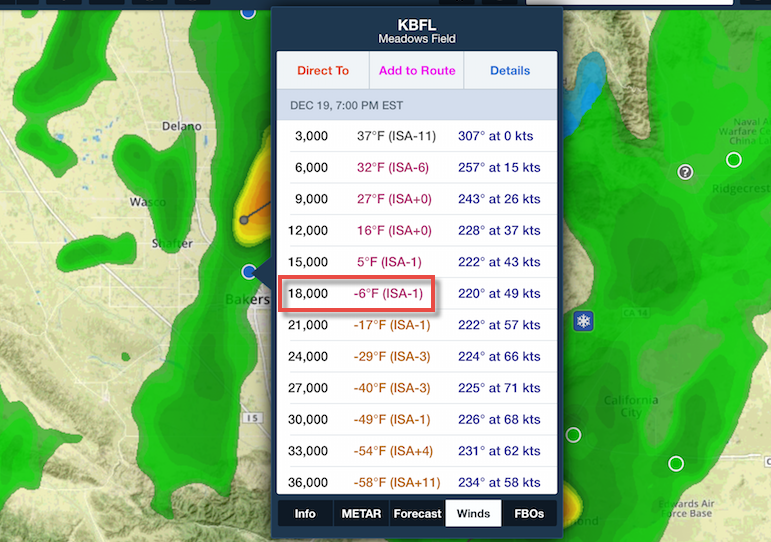
Once the cloud top temperatures are known, it’s a simple process to compare this cloud top temperature against the temperatures aloft using ForeFlight. Below are the Winds and Temperatures aloft for Bakersfield near one of the more intense cells at this same time. This clearly shows at 18,000 feet MSL the temperatures were -6 degrees Fahrenheit or -21 degrees Celsius. So cloud tops in this region were definitely below 20,000 feet.

If you were paying close attention to the radar loop, you may have noticed that one lone echo top height marker appears (pointed to by the red arrow below) of 201 indicating an echo top height of 20,100 feet in this cell. So when you see a lack of echo tops reported, it just may be that those tops are below 20,000 feet.
